When I headed to Lombok there was only one thing I really wanted to do, trek to the Rinjani’s crater rim. Little did I know back then that aside from Rinjani, there is another hill, even though nowhere near as high, that also opens up to some epic views that I’ll be remembered for weeks and months to come. This place was Pergasingan hill or as the locals know it, Bukit Pergasingan.
Where is Bukit Pergasingan
Pergasingan Hill is located about 1-hour drive away from Senaru, in the village of Sembalun in North Lombok. To get to the start of the trek, there really aren’t many options when it comes to transport especially if you want to see the views for sunrise which is what I strongly recommend that you do.
To get to Bukit Pergasingan, either rent a scooter or arrange for a driver to take you to the base. Renting a scooter from Senaru will be an adventure in itself because there aren’t actually any formal rental places in the village. What I and my friend had to do was haggle (hard! 😀 ) with one of the guys at Dragonfly Senaru Lodge in Senaru where we stayed after our hike to Rinjani. We had to convince him to get his friend to rent us his scooter for a few hours so we could drive to Sembalun and do the hike for sunrise.
It was actually quite hilarious because we were literally gonna get this guy’s personal bike with no helmets, insurance or anything to formalise the “rental” 😀 ! And because no formal rental service exists in Senaru, locals go wild on the price when they pick up on someone as desperate for a scooter as we were. A scooter in Indonesia costs around IDR 50-60k for a whole day. These guys wanted 200k initially for about 5 hours 😀 . Locoooo! After a hilarious debate, we settled on a final price of 100k which was still a rip-off but hey, what can you do, they had us 😀 !
When driving to Bukit Pergansigan, follow the Google maps directions until the point where you can’t go any further. Then you’ll have to cross a little bridge to get you over the river at which point you should see a sign saying “Selamat Datang di Kawasan Wisata Bukit Pergasingan”. At this point, you need to have downloaded Maps.me (search for Gunung Pegasingan, without the “r” for some reason) because Google maps stop with the instructions at this point. After that, we heavily relied on Maps.me to show us the trail up the hill and honestly it works.
Trekking to Bukit Pergansingan
Our alarms went off at 3:30 am. We had just finished the 2D1N trek to Rinjani the day before so as soon as the alarms went off, all we wanted to do was throw something at the buzzing phones and go straight back to bed 😀 We were exhausted but we had paid for the scooter already, were already up so there was no going back but to put some clothes on and hit the road on the way to Sembalun. It was cold, dark and literally dead the whole way from Senaru to the base for the hike. The only thing we could hear were the somewhat creepy mosques that were filling up the silence in pretty much every village that we passed by. We saw only a handful of people who had probably just woken up to open the fast as it was around 4 am during Ramadan.
Even though we were on the main road for the majority of the drive, the road was getting worse and worse as we were approaching the base so don’t be fooled and drive slowly as a seemingly good road was quickly turning into an offroading trail. About an hour later we were at the base so we parked the scooter and headed towards the trail.
As soon as we crossed the little bridge mentioned above, passed the sign for the park and turned on Maps.me, we took a left to start the trek up. The start of the trail isn’t necessarily well marked so it was easy to miss it if it wasn’t for Maps.me to show us that we had to go left.
The path starts off with a very steep set of stairs which goes on for quite a bit until the stairs completely disappear to make room for rocks and dirt which lead all the way to the top. Numerous times we had to grab a hold of bushes, roots and rocks to lift ourselves up as we were making bold wide stretches to keep moving forward and up.
As we were hiking for sunrise, it was pitch black. Luckily my friend had a headlamp and I had a good torch on my phone which brought in some light but having to hold my phone and hike up proved quite challenging as I often needed to hold myself onto something to keep my balance going up.
After 30 min into the hike, the trail levelled out quite a bit and it was no longer the hard steep trek that we had originally started off on. We were still going up but along a much easier, slowly elevating path, covered in thick bushes on both sides, which was leading us up to the higher points on the hill. The further up we went, the more the views were starting to make an appearance.
The sun was slowly starting to rise as the clock was already striking 5:30 am and we were slightly getting concerned that we wouldn’t reach the summit until 6 am even though we had read that the trek should take about an hour. Maps.me however, was showing that the summit way further up but luckily as it was already getting brighter we could pick and choose where to stop to take in the views. After about an hour and a bit of hiking, we found our perfect spot. We didn’t reach the point marked on Maps.me as the summit but the trail was now almost entirely flat so we didn’t feel the need to keep going further along the trail.
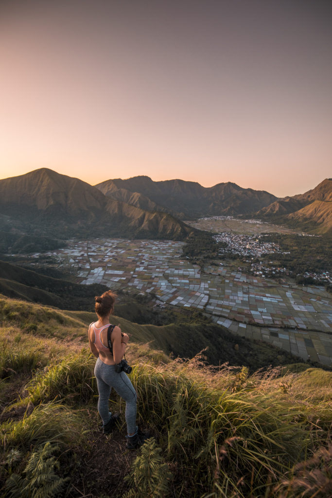
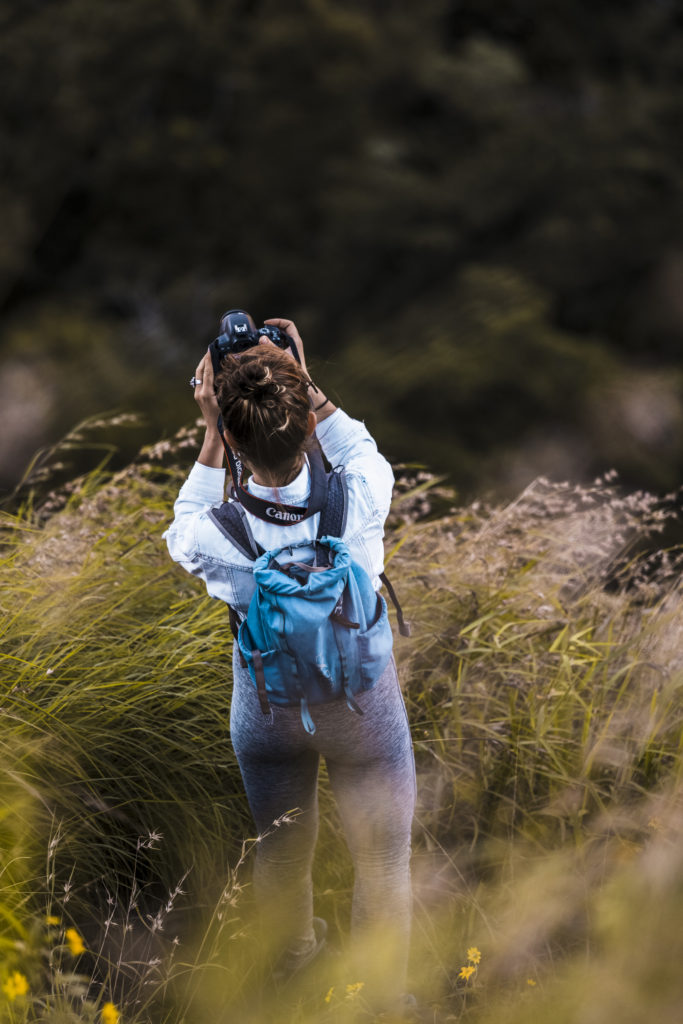
We took out the cameras, armed ourselves with patience and eagerly started to look towards the left as the sun was starting to rise on the horizon. I had seen a handful of photos from this peak but never did I expect the views to be so impactful once I got the chance to stand on the hill and take them in with my very own eyes.
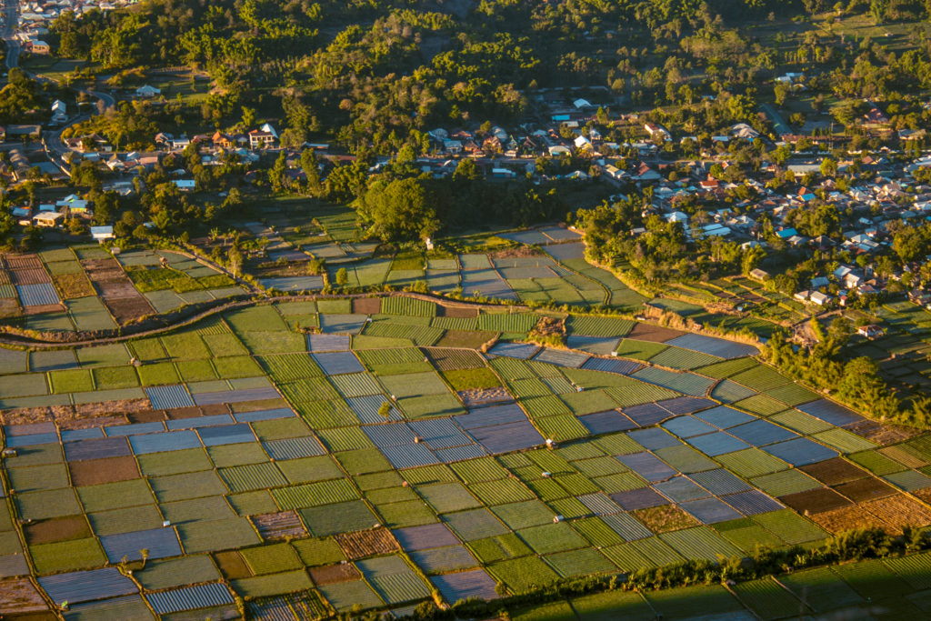
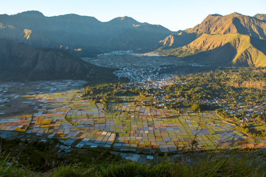
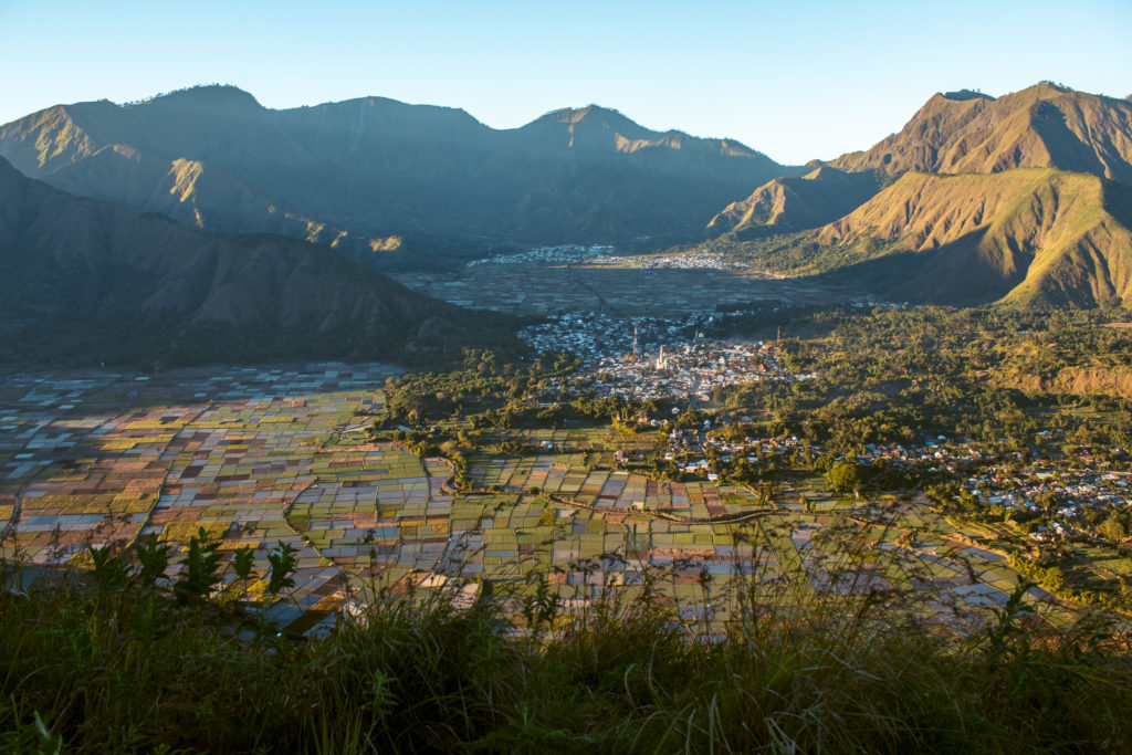
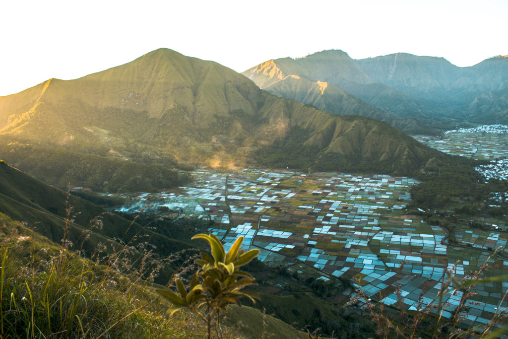
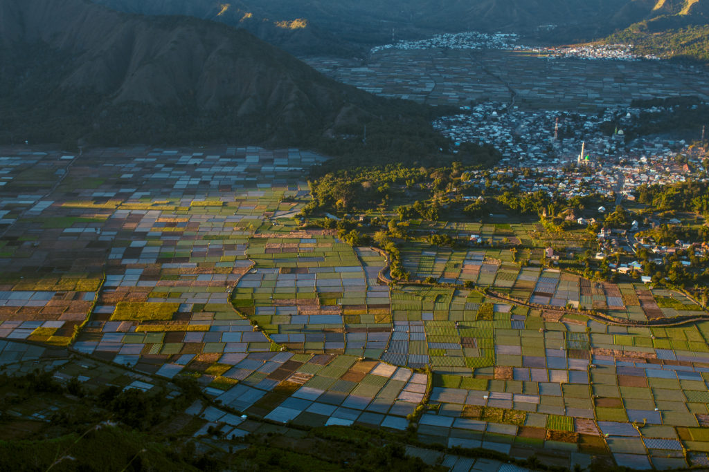
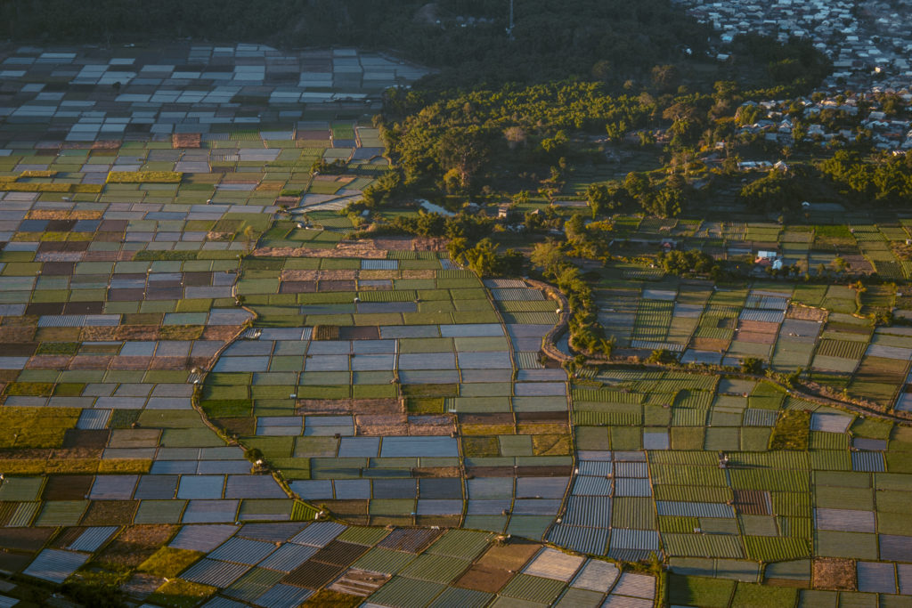
Far into the distance, we could see the views over Sembulan. The village mosques were standing out gracefully among all the other structures in the village and setting the tone for the morning prayers in what was a very religious part of the country. Right down into the valley, almost as if painted on a drawing pano, were patches of multi-colours farmlands, arranged diligently one next to the other in a perfect painting featuring various nuances of green, brown and white. Honestly, for a few short moments, I and my friend were starting to question whether these views didn’t beat the Rinjani views we had sweated to get to just the day before.
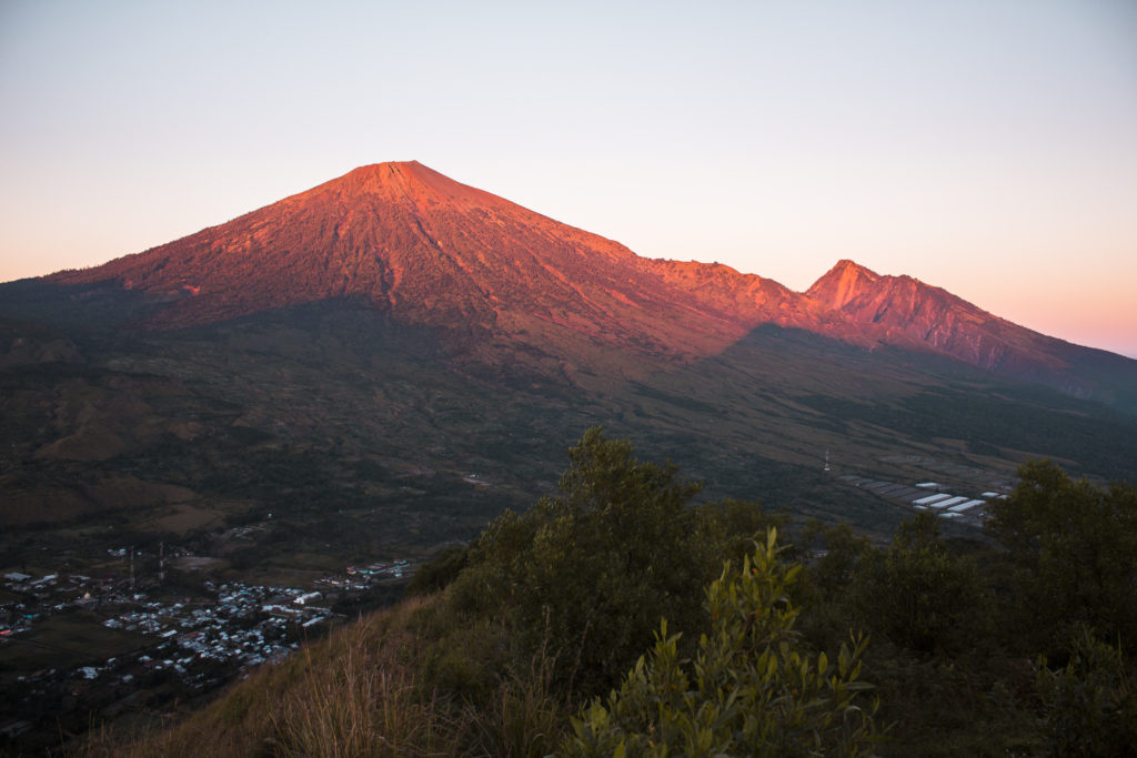
To the right, mount Rinjani was firing up in red bold tones as the sun was starting to shine right towards it. Left, right and straight into the horizon, layers of hills perfectly scattered one after another were throwing me right back to the photos I had seen of a friend who had explored Hawaii and its endless jagged hills. I have been wanting to see such majestic, sort of weird rugged hills for a while and whether it was Hawaii or Bukit Pergasingan it really didn’t matter because the views left me speechless regardless.
I was going up and down, left and right, as I was rushing to take as many photos as I could until the sun rose up and haze settled above the spectacular views. I was like a kid who knew she had enough already but still couldn’t stop to take in even more. I would put my camera away and take it back out a few seconds later. That’s how amazed I was at the change in the views as the lighting started to alter with every bit of travel of the sun higher and higher on the horizon. It truly was a phenomenal experience, one that proved to me again that turning down an adventure is never a real option.
Happy, humbled by how small we felt in the grandness of the mountains and the volcano surrounding us, we eventually packed up the cameras and started to head back down on the same path, this time taking us just about 30-40 min to get down.
As soon as we reached our scooter as if the whole village had awakened whilst we were taking in the views from the hill. Kids were running around, chickens were boldly crossing the roads, ladies were feeding their babies whilst men had already started the daily works on rebuilding the houses and roads of the village. Another day had begun and we were fortunate to have seen it unfold some few hundred meters above the ground.
Where to Stay in North Lombok
North Lombok is definitely adventurers’ favourite part of the island with easy access to Rinjani, Bukit Pergasingan and the Tiu Kelep and Singala Gila waterfalls. I personally stayed at and recommend the following two places.
Rinjani Lighthouse – This is the place we stayed at the night before we hiked Rinjani with Jou Trekking. The place was absolutely beautiful, with gorgeous views over Rinjani, tranquil gardens, all bamboo structures and staff so polite they even offered us a welcome drink with creamy cookies to settle us in after our trip to the island. If you want to proper rest before your Rinjani and Pergasingan treks, this is the perfect treat!
Dragonfly Senaru Lodge – This is a budget but still value option with rooms overlooking the mountains and Singala Gila waterfall. The rooms are basic but the gorgeous porch with comfy seats makes up for the lack of AC and somewhat cold-ish shower. It’s definitely a great option (with breakfast included), if you’re not looking to spend more than IDR 200k a night.
Looking for more articles on Indonesia?
Liked this post? Pin it for later?
Hello, Marchela!
Bukit Pergasingan looks absolutely gorgeous. The pictures you took are amazing and it looks like you had the best time exploring the place.
Aaaw Arunas, thank you so so much for your comment! Bukit Pergasingan really is a wonderful place, one of the best short hikes I’ve ever done and I truly had a wonderful time! Hope you’re enjoying your travels as well and keeping safe!
Aaw Arunas, thank you so so much for your comment. Bukit Pergasingan truly is one of the best short hikes I’ve ever done and I really had a wonderful time. I hope you’re enjoying your travels as well and keeping safe!!